
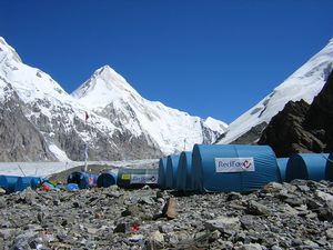
Inylchek — natural and ecological complex of highlands.
Actually, the nature has such landscapes which that can not be precisely defined. Thus, the majestic mountain site of Muzdag — «Ice Mountain» is a clear confirmation of it. It is located in the most extreme and highest point of the Central Tien Shan, near the borders with Kazakhstan and China. Its territory includs a huge area of mountain ranges of incredible beauty, the most popular of which are the Peak of Pobeda and Khan Tengri – both of 7000 meters, and alpine glacier, named Inylchek and the highland Lake of Merzbacher.
 Grand view opens from a helicopter on approach to «Ice Mountain», everywhere you look down the white realm of eternal ice stretches, and mountain ridges, just like the teeth of predatory sharks, ripe blue skies. A look at once distinguishes two main peaks of Muzdaga — Pobeda Peak and Khan-Tengri, which like brothers are situated opposite each other…
f you look, the peak of Pobeda is not the mountain, and certainly not rock, it is a huge mountainous area. It takes the start at the junction of the highest Tien Shan ridges — Kokshal-Too and the Meridian, in the place of the connection the height reaches 7003 meters — that is the eastern point of Pobeda Peak. From this place, the crest goes to the west, some going down, then shoots up rapidly, forming the peak of Soviet Armenia, and after a short descent goes to the highest point of the ridge.
The main top of Pobeda Peak is quite unusual — it is a fairly sharp ridge, icy in the west and rocky in the east, a length of about 1500 meters. To the west it goes by ledges, dropping to an altitude of 6900 meters and below. This continues until a new small increase at the height of 6018 meters. Actually, this top is considered to be the ends of 10 kilometers’ «three-headed dragon» – the Pobeda Peak, and its «tail» the array of Kokshal Too continues to the west, leaving several new «gifts» for climbers with a height of 6744, 6565 and 6088 meters.
At the same time, its brother — Khan-Tengri Peak, according to opinion of many experts, is one of the most beautiful peaks on the whole earth. In appearance it resembles a child’s drawing — almost perfect pyramid of marble, covered with a shroud of non melting ice and snow.
The mountain is situated right on the border between Kazakhstan and Kyrgyzstan, and is considered to be the landmark of both countries.
Originally from the Uighur the name of «Khan-Tengri» is translated as «Master of the heavens» or «Father of spirits,» is due to the fact that in ancient times the mountain was worshiped as a god. Still, who saw the Khan Tengri at sunset, would never forget the holy terror that with an ice stream flowing down the collar, when the eyes see the sight of a giant rock painted with the setting sun in monstrous purple colors.
The first mention of the peak can be found in Chinese chronicles over 1200 years ago, and the first conquest of the giant, took place in 1931 year by Ukrainian climbers.
And since then, as the saying goes: «the popular trail does not overgrow.» Khan-Tengri and Pobeda Peak are, without exaggeration, the most popular sites in the Tien Shan among mountain climbers around the world, a kind of mountain Mecca.
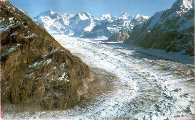
 Right at the foot of Khan Tengri the glacier of Inylchek creeps like a giant snake crept back, wrapping around from two sides the giant, taking the top of it into the icy captivity.
It is the largest and fastest glacier in Kyrgyzstan and the second largest in the CIS.
Yes, you understood correctly, it is really fast. Profoundly mistaken are those, who think that the glacier is something eternally frozen. They are alive and they are moving constantly. There are slugs among them, but there are also «speeders», and the rate of relapse ranges from 10 to 200 meters per year.
As you already understood, Inylchek is divided into two branches — North and South. Thus, namely the Southern Inylchek is considered to be the largest in the country. Its length is nearly 60 kilometers, and the occupied area — is 572 square kilometers. The «tongue» of the glacier is about 43 kilometers long, with an average width of 2.2 kilometers and it down to 2800 meters. At the same time, the thickness of the ice shell on top reaches 500 meters, and in its lower layers — something about 150-200 meters.
At the bottom of the «tongue» is covered by sediments of earth and stones, there daisies-Richter and edelweiss grow. And in the upper side, there are frosts up to-30C even in summer, winds blow, heavy snowfalls do not stop.
In the course of its flow, the glacier is divided into several tributaries that go to the northern spurs of the ridge Kokshal Too. They live their own lives and even have their own names: Asterisk, Wild, Proletarian tourist and Komsomol.
The Northern Inylchek in its movement goes away to the west for a distance of 30 kilometers and is lost between the ridges Saryzhaz and Tengri-Tag. Its scale is not large as the Southern one, but, according to mountaineers is more difficult to reach and cunning.
In general, the glaciers of Kyrgyzstan take almost 4% of the entire country, the value of them is enormous, and can not be overstated. They contain more than 650 cu. of fresh water, they give a rise to mountain rivers and lakes. It is they owe the lives of many oases of Kyrgyzstan, Kazakhstan and Uzbekistan.
At the foot of Khan-Tengri peak, at an altitude of 3,400 meters above sea level, there is another component of the complex «Inylchek» — Merzbacher Lake.
This is an absolutely mysterious object of nature. This lake just like a giant bathtub drains itself periodically.
Such lake was discovered quite accidentally. In 1902 year, the expedition of German geographer and climber Godfried Merzbacher set off to learn Muzdag. And here, in a remote place, at the foot of Khan Tengri, they discovered a small lake, squeezed in a snowdrift between glaciers of the North and South Inylchek. Come to him the team of researchers was able only after exhausting 12 kilometers’ crossing through the Southern branch of the glacier.
Lake can not boast of large size. Its length is 4 only kilometers, while the width of it is 1 kilometer and a maximum depth reaches 60-70 meters. The banks of the reservoir are formed by steep cliffs going down, and the entire surface of the water is dotted with floating ice blocks. Depending on wind direction, they then disperse throughout the lake area of build up from one of the banks. Their huge peaks thaw under a bright sun and collapse with a crash into the water, they roll over, sink and emerge again, in general, behaving just like real icebergs.
But one day, which most often occurs in August or September, you will not be able to catch the idyll of floating ice. Your eyes will find out ugly picture of an empty bowl with debris of iceberg blocks scattered around the lake on the bottom.
This means that the water is gone and the lake, once again, not looking at a powerful ice «dam» in its basement, dumped the water.
 It happens every year. As soon as the bosom of the lake is filled with melt water, an unknown mechanism triggers and the water just drains way somewhere under the glacier.
250 million cubic meters of water with the noise and roar for a few days pour out from the mouth of the lake and 15 kilometers below the «dam» digging out, forming an uncontrollable flow that fills the valley of Inylchek river. Discharge of water takes the character of the catastrophic floods, with irresistible force the rushing rapids along the river bed, during a few hours to overcome a distance of 50 kilometers, and flows into no less raging torrent of the Saryzhas river. Only in the territory of China water weakens a little, becoming one of the components of the Great Yellow River, and after that almost deliberately carries its waters to the ocean.
Generally speaking, in relief of melt water by alpine ponds is not surprising, but in the case of Lake Merzbacher, all the natural mechanisms that trigger this process are turned upside down, and scientists still have not found the answers to obvious questions.
At what point and why does a spillway start? Where the drainage channels and what plays a role of valve? Why the valve is closed during the filling of the lake, and how the lake can be filled during the snow melt, because it is such a short period?
These and other questions are yet to be answered by scientific expeditions that set out to explore the phenomenon.
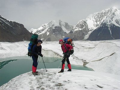
But you had better luck, because you can visit this fabulous region as a tourist. And only small thing is needed for this: a bit of firmness and perseverance, desire and youthful exuberance, and then no peak in the whole world, no ice, and even moreover, no ice lake, can resist you, and we in our turn, are always glad to help you with this.