
 The Fan Mountains are a popular tourist destination situated in north-west Tajikistan. The Fan Mountains area is convenient for visiting. A paved road from Dushanbe going to the largest Pamir-Alai lake — lake Iskandarkul — leads to this place via the 3,372m Anzob Pass. Another paved road runs from Panjakent. One more road from Khujand runs through Istravshan (formerly Uroteppa) and the 3,351m Shahriston Pass. The Fan Mountains area road system includes both paved and unpaved roads.
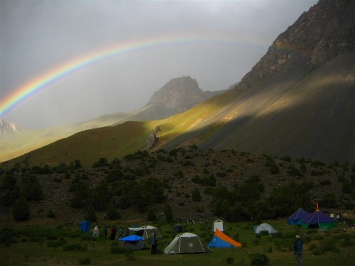
The area is ideal for organizing hiking tours lasting several days. Going from one valley to another, from one beautiful lake to another no less stunning, via numerous rocky outcrops with occasional hanging glaciers, tourists can’t help but recognize the fantastic environment through which they are travelling.
Among the most beautiful and interesting peaks (from a mountaineer’s point of view) are Chapdara (5,050m), Bodkhona (5,138m), Zamok (5,070m), Maria (4,970m), Mirali (5,120m), and Zindon (4,800m). Both the good and the ordinary routes on the south and west sides of Chimtarga (5,487m), the highest peak of Fan Mountains, lead to its top.
 Besides the high peaks and narrow valleys with their noisy streams, which are typical for the Fan Mountains, there are also about 30 clear lakes of a variety of colours.
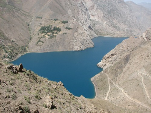
To the south of the main range is Lake Iskandarkul — 2.5km in length, 1km wide, and about 72m deep, at an altitude of 2,255m — on the shores of which a hostel with the same name is situated. Apparently this lake came into existence several thousand years ago as the result of a landslide. The water in the lake is bluish-green, slightly turbid and very cold, so only the bravest dare swim there.
From the north the Serima River flows into the lake, from the west, the Saritag River (with the larg est volume of water), and from the south, Hazor-Mech River. Only one river, Iskandar-Darya, flows out of the lake. It has a waterfall which cannot be seen from the road and one has to come close to it to enjoy its charming beauty. There are almost no fish in the lake because of the concentration of minerals in it. Only small loach (similar to catfish) survive in such water.
Next to the lake is Chulboi Mountain (3,358m), also known as Dozhdemernaya (Rain Gauge) Mountain. It was called this after a precipitation gauge was set up near the mountain top. There are good paths leading to the top, which is flat and covered with grass. A panoramic view of Lake Iskandarkul and its vicinity is visible from there.
Iskandarkul’s flora is not particularly abundant but it is exceptionally diverse. You will come across forest, steppe, meadow and high mountain flora (everything from apricot-trees to moss and lichens) there.
Near the lake one can sometimes see rabbits, foxes, wolves, red marmots, black and brown bears, mountain goats and their companions — palang (snow leopards) and other animals. As for birds, mountain turkeys (snow cocks), stone partridges, griffons, and quails are also found here.
 Many legends are connected with Iskandarkul. According to one of them, Alexander the Great, during his march to India, reached the lake and camped on its shores. After a very hard march through the mountains, his favorite horse became sick after drinking water from the lake. He did not wait for it to recover and continued his march, leaving the horse with several soldiers on the lake shore to recover. After a short time the horse recovered, but one day it suddenly behaved strangely and threw itself into the lake and sank to the bottom. Now, during full moon, it is possible to see a white-manned horse coming out of the lake, which grazes and plays in nearby meadows all night long, then at dawn returns to the lake depths. According to local legend, Alexander’s horse went to the bottom of the lake, anticipating the death of its master, who fell ill and died on the way back from India. Unlike Iskandarkul, the Bolshoi (Greater) Allo Lake (3,360m) in the Zindon Valley was formed relatively recently.
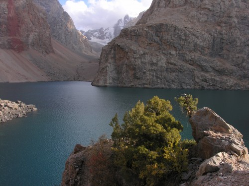
 In 1916 there was a large rockfall from the southern slopes of the main range which blocked the valley. The dam was formed from ancient moraines blocked by this mighty landslide. «Allo» in Tajik means «echo». On the right and left sides of the lake are sheer cliffs, on the north, scattered giant blocks and on the south is a bottle-neck, where the Levy (Left) Zindon River winds its way over the slippery rocks. It is possible to see rare flowers such as edelweiss (Leontopodium alpinum) near the lake. On its left shore the vegetation ends and further afield a stone desert begins, resting on the cliffs of Moscow Peak (5,183m). The Lake is also near other peaks over 5,000m — Mirali, Chimtarga, and Energiya. To the north, where glaciers once lay, is Lake Kulikalon and its neighbours — Chukurak, Ziyorat, Bibi-Jannat, Dushoha as well as the popular Alauddin lakes (2,700m) with a mountaineer’s base. Lake Kulikalon (big Lake) is situated at an altitude of 2,800m, and is the second largest lake (after Iskandarkul) in this area. The lake actually consists of two lakes: Bolshoi (large) Kulikalon and Maly (smaller) Kulikalon, which are connected by a channel. The northern shore of the lake is indented with large and small creeks separated by capes and crevices. The lake shores are wooded. The water from Maly Kulikalon goes underground and emerges again 600m below as the Urech River. The water at the southern end of Bolshoi Lake is noticeably cooler than at the northern end where it is possible to swim. Its colour also changes near the shores. It looks as if the black bodies of dead animals lie motionless in the bluish-green water. There are marinka (Schizothorax) fish in the lake. There is a good trail along the lake’s western shore but the eastern shore is difficult to traverse due to rock falls. Over the Bolshoi Lake there are abandoned fluorite quarries in which it is possible to find beautiful gemstones.
 The Alauddin Lakes are a group of reservoirs upstream in the Pasrud valley. All the lakes are situated on the steps of ancient and modern moraines. Pure, clear water pours from one step into another and the level of water in the lake remains constant. There are no fish in the lakes. Only the most experienced and adventurous will bathe in the water for any length of time since it is very cold.
It is possible to set up a base camp not far from the astonishingly blue Alauddin lake. Along all of its shores there are juniper forests and the reddish 2km-long Chap-dara Wall overlooks the splendour below and its large rock falls. If you climb the Alauddin Lakes Pass then you will see the lake in all the various shades of blue: from light-blue near the shore to dark-blue in the middle with clear borders separating the various shades.
 Higher up the Chapdara River there is a beautiful view of the valley with its majestic rocky bulwarks on both sides. The Chapdara Wall faces north-west and hence reflects an astonishing gold colour during sunset.
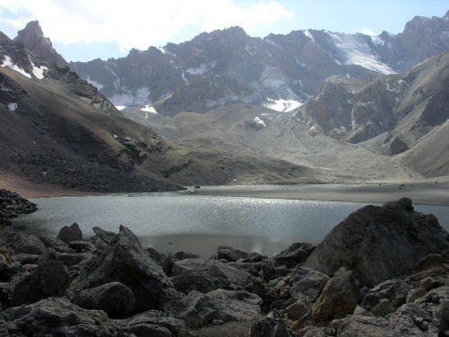
On the opposite side of the valley is the Adamtash (Stone Man, 4,940m) massif with vertical bulwarks on its north-west face. From the mountaineers camp a route leads along the northern ridge directly to the top. If you climb up from the lakes along the valley then within two hours you will reach the beautiful Mutnye (Muddy) Lakes (3,490m), located in the circle between the slopes of two mountains — on the western side Zamok and on the eastern Chimtarga. The vertical bulwarks of Bodkhona and then Zamok, riding one after another, appear to your left as you cover the two last steep ascents.
The north-eastern Chapdara Wall rises from a side valley located a lot lower than the base camp. This is a 1,500m, almost vertical, smooth, rocky cliff-face. It ends with a huge semicircle and opens up the to the whole Fan Mountains region — a wonderful sight for those who have braved the 10- 12 long hours of snaking mountain roads built along the tops of cliffs hundreds of meters deep.
A very pretty view begins at the Kaznok Pass (4,000m) on the incredible south and west cliffs of Chimtarga Peak with a formidable sub-peak bulwark, through which a number of complex rocky routes run in parallel. Mutnye Lakes is a good base camp from which to attempt these cliffs. There is no vegetation in the lakes area; all that exists is rubble.
The grand northern cliffs of the Adamtash (with a 1,000m cliff-face), Maria and Mirali (with 1,500m cliff-faces) enclose the valley, hanging over the scenic Dush-okha Lake each with its formidable magnificence. There are actually two lakes — the Upper and the Lower with a narrow strip of land between them.
 The two-hour climb up from Lake Kulikalon will take you to the grand northern cliff of Maria Peak, which has a complex combination of routes and its own cold microclimate with a cliff-face of more than 1,500m.
Alauddin Peak (4,237m), rising to the west of the Alauddin lakes, serves as a good point from which to view the area and can also be used for the first part of the climb from Alauddin Pass (3,730m). It is practical to camp here overnight to acclimatize (it is 2-3 hours walk from the lakes).
The Pravy (Right) Zindon Valley, the northern cliff of Zindon Peak («Prison Peak» — 4,800m), encloses the surrounding area, making the scenery gloomy. The 1km vertical cliff with an ice «ceiling» at the top can be very intimidating. Climbing becomes hard here since the rocks are always damp — water flowing down leaves black marks on the cliff.
The Marguzor Lakes are small reser voirs including Nezhigon, Soya, Gushor, Nofin, Khurdak, Marguzor, and Hazorchashma. They are situated in the south west branches of the Zarafshon range, 2-3 hours drive from Panjakent. The difference in al titude between the upper and lower lakes is 692m. All the lakes, except for Hazorchashma Lake, were formed by the creation of dams.
Marguzor Lake, the largest lake of the «Seven Beauties», is 4.5km in length, 45m in depth, and its water is a fine shade of blue. The lake sits at 2,200m above sea level. Near the lake you can see primitive people’s drawings on limestone blocks. There are also the remains of an ancient mine where it is easy to gather rare and unusually-coloured stones. The nortnern slope»of Marguzor Lake dam is a dense grove of high trees and fragrant herbs, and creeks running through the body of this natural dam.
Lake Nofin stretches for 2km with a width of 400m and has greenish water.
There are deep caves near the harsh and cold Hazorchashma Lake. In one of them is the Iceland spar, and you can also find rare minerals here such as malachite, rock crystal, and antimonite.
The water in Lake Soya is an astonishingly beautiful colour. The water fades through all the shades of blue and sometimes even appears purple. At the bottom of the lake you can see stones through water which change colour according to the position of the sun.
Nezhigon Lake is the pearl of the whole Marguzor Lakes chain. It is not very big and is surrounded by cliffs. The turquoise water which fills the deep hollow appears frozen. An overhang from the snow-topped mountain above the lake shines like a halo and is very pleasing to the eye. The water in the lake is warm enough to swim in.
The flora and fauna of the Fan Mountains area is fairly unique. There are more than 2,000 species of plant here, including many medicinal herbs. Up to 2,200m there are many orchards where walnut, poplar, birch, sallow, hawthorn, sea-buckthorn, barberry, dog-rose, and currant bushes grow. Above 3,200m the trees disappear and the mountain slopes are covered by alpine meadows.
The snow leopard (ounce), white-claw bear, mountain goat (teke), argali sheep, wild boar, wolf, fox, rabbit, marmot, ermine (mustela) is just a small sample of this mountain area’s wildlife. As for birds, there are mountain geese, snowcocks, partridges, pigeons, eagles, gryphons, hawks, and many others.
Since ancient times, the Fan Mountains’ valleys have been populated by highlanders. When you look at some villages on the steep slopes, it appears that the whole mountain is one high-rise building. Flat-roof houses go up the slope step-by-step in such a way that the roof of those living below serves as a courtyard for the people living above.
Visiting the Fan Mountains will fill you with true delight since within just a few hours you travel from juniper forests and rich vegetation to a zone of glaciers, uplands and perpetual snow.
Besides hiking and mountain-climbing, there is the possibility for this area to develop water tourism (rafting) and biking, paragliding, downhill skiing and other exotic forms of recreation.
The best time to visit is between the second half of June and October when the weather is usually dry and warm, and the sun shines brightly the whole day. Sometimes, even at the relatively low altitude of the Kulikalon lakes (2,800m) it can suddenly snow, even in midsummer!
In November — May there is a high risk of avalanches on mountain slopes and numerous mountain passes become practically inaccessible.