
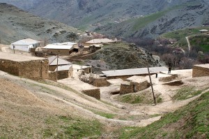
 The village named Uhum which is near Hayat and Nurata Mining Nuciferous Reserve is at the down part of Uhumsay, along its coasts. Upside part of the village is different from those one could see before. Here are peculiar stone and clay houses of local farmers, curved streets with whimsical mulberry trees, the interesting wrinkles of rock — shale, the ruins of ancient settlements, walnut groves, cemetery local saint “Bobo Eshonov”, petroglyphs depicting a hunting scene on the sheep Severtzov. People’s job here is limited by agriculture, gardening and animal husbandry. You can hardly see any man near the home at the day time in here because all of them are working. Some of them go up to the mountains with animals; others are busy with either agriculture stuff or just working for their own gardens. Reconstruction and irrigation are also typical for these places. Women’s responsibility is to take care of the house. Their kids play all around the house. The cows and goats roam everywhere around, while watchful Middle Asian shepherds carefully look after them.
 Everywhere in Uhum you can find a type of constructional material which is pretty much common for this area. Almost all mountains have it. That raw material, water availability, and abundance of vegetation and animals were the reason of human living in here. Ancient hunters left special pictures — petroglyphs for further generation. You can see them almost in every piece of Nurutau Mountains. The nature and surrounding environment gave a man a very comfortable material – a stone. Earlier it was used as labor tool, and sometimes as canvas. After that stone was used during the constructions of the houses. The way the houses are build and their architecture style are especially interesting. On the hillside residential stone houses with clay-timbered ceilings, located at different heights, and surrounded with little stone walls. Local clay is used as a fluid.
Pretty much developed system of paths and little roads of the saes should be highlighted. As local population says they were built and constructed long time ago. AT the old times there were no high technology and all the work was done manually. Nowadays when building of highways is needed then mountains slopes are just being broken. AT those times, on the contrary, people put flat stones in one line all together so that the road would be sort of straight. But they did not put any cement. At some points the roads were fixed by woods. The lowest point of these roads was serving as a fence for the gardens at the same time. The curb was filled in with dry tree branches, and so it prevented the animals’ encroachment to the fields.
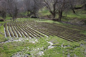
 Starting from the downside of the Uhum village you can see gardens, yards with the flat roof houses. Many inhabitants of the village do have lands. The road is clean and comfortable to go through. All the way to the deep canyon you can see the mulberries. And right at the sai, its neighbor lawns there are small yards for future buildings. You can find really old walnuts in there. Soon at the top the mountain cliff “Parandos” can be observed. The topography of these mountains is a very disjointed and complicated, which adds a special beauty, diversity and uniqueness to it.